Bhutan – Snowman Trek I
Tour - 33 days/ 24 day trekking
About BHutan
Region
Bhutan
Best Time
April-June &
mid-Sept - mid-Nov
No. Of Days
33 days, 24 days trek
Trip Character
Jeep tour with trek
Sleeping Altitude
1400 - 4220 m
Trek Character
Camping trek
Level: 3
Price
INR XXX/ $ XXX
ABOUT THIS TOUR
Bhutan is not your average destination. And that’s the understatement of the century. For starters, it’s the only remaining Buddhist Himalayan kingdom, the only one that managed to escape assimilation by either China or India. Being only the size of Switzerland and having just over 700,000 inhabitants, that’s quite a feat in itself.
Bhutan is mainly known for its very original culture and nature. This is largely due to the centuries of isolation, but also to the deliberate policies of the present government and of the kings in the past. Until the seventies, hardly any foreigner ever had set foot in the secluded kingdom.
Read more…Read less…
HAPPINESS OVER WEALTH
However, in 1972, at the occasion of the crowning of king Jigmed Singye Wangchuk, many foreign guests were invited to Bhutan. Having studied in the U.K., the future king obviously saw it coming that especially the western guests would observe a discrepancy between their own standard of living and that of the Bhutanese. In his opinion, the Bhutanese were not poor, but merely lacking in some amenities and products available in the West, most of them non-essential. Otherwise, the Bhutanese were actually quite well off, he felt. Almost all of them had a beautiful, spacious farmhouse, more than enough forests, arable land and animals to be fully self-sufficient in terms of heating, construction and nourishment. And, most importantly, a culturally defined sense of identity, belonging and security that made most of them very content and happy beings. The king had observed otherwise in the west.
In order to explain this to his foreign guests, he coined the term ‘gross national happiness,’ a clever term obviously meant to be juxtaposed with what seemed to be the aim of most governments, a high gross national product. The rest is history, one could say. These days, all over the world, conferences and workshops are being held on happiness and, more in general, on how to develop and emphasize those qualities of life that can not be measured in dollars or euros.
Bhutan does not claim that its inhabitants are the happiest in the world, but it does place overall happiness above wealth. These days, GNH, as it is generally referred to, is the formal pillar and yardstick of all government policies. After the king abdicated his powers in favor of a democratically elected government, Bhutan has seen four governments. All of them have continued to place GNH above anything else.
As a result, Bhutan has protected its culture – largely defined by Buddhist beliefs – but also its forests, mountains, rivers and wildlife much better than any other country in Asia. Key to all this is a reliable, non-corrupt government, which itself is one of the four pillars of GNH and, frankly, quite the exception in the region.
On your trip through Bhutan you will see numerous temples, monasteries and dzongs (monastery castles), better preserved and more lavishly decorated than anywhere else in the ‘Tibetan’ realm. Not less impressive, if alone because of their rustic beauty, are the many traditional houses, as well as meeting the friendly, warm-hearted people who embrace their culture as a precious heritage.
Read more…Read less…
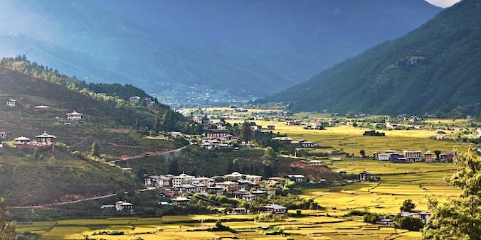
Bhutan is also extremely mountainous and rich in nature, especially forest – in fact, it is the most wooded country in Asia. The southern border consists of hills and low mountains with dense jungle where elephants and tigers roam, and people live in bamboo houses surrounded by rice fields. But in the central highlands, at an altitude of 1500 – 2500m, people live in small enclaves of farms reminiscent of Swiss chalets, surrounded by endless coniferous forests. Travelling through this area (and when you fly over it) you will occasionally catch a glimpse of the northern and highest parts, where the semi-nomadic yak shepherds live and which are bordered by glacier-covered Himalayan peaks. The only way to see all this up-close is to set out on a seven-day (or more) camping trek. This is exactly what you’ll be doing on this tour.
YOUR custom-made TRIP
The tour described here, as well as the other ones on our website, are mainly meant as suggestions. We would be happy to offer you a travel proposal that fully meets your personal demands and expectations. That means that you choose where you want to go, what level of accommodation and type of transport you want and what activities you prefer.
Please let yourself be inspired by this and other trips on our website and then drop us a line (or call us up) to explain your travel wishes. We will be happy to help you put together the perfect trip. You can reach us over e-mail, Messenger, Whatsapp or mobile phone.
EXTENSIONS & VARIATIONS
Apart from the tour as described here, you could consider the following add-ons and changes:
- On this tour you’ll spend about 8 days on exploring the cultural highlights of western Bhutan, before and after the trek. In case you would rather keep the tour length to the bare minimum required to do the trek, we can leave out most of these days. You would still need two days for acclimatisation and another two days for returning from the end of the trek to Paro, the total length of the tour would then be reduced by 5 days, bringing it down to 28 days.
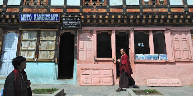
- Spend another day in Thimphu at the end of the tour. Because, although Thimphu is by far Bhutan’s most ‘mundane’ place, it has a lot to offer in terms of culture, restaurants and cafes, shopping, and a very pleasant atmosphere.
- In terms of cultural sights, Punakha also has a lot offer. Another day here is definitely worthwhile.
- If twenty-four days of walking seems a bit much to you, you can consider a much shorter, but similar trek, such as the Jhomolhari Trek (9 days) or the Soi Yaktsa Trek (7 days). These treks are also off the beaten track, leading along time-warped, isolated villages and high yak pastures.
- Spend a day rafting on the Paro River. There are different grades available, so there is the easy-but-fun-to-do level as well. Professional oarsmen will be with you in any case. You will be picked up from your hotel and dropped off there again at the end of the day, a pic-nic lunch is included.
ITINERARY
-
.fa-info {color: #1146a9;}.fa-info:hover {color: #387dff;}Day 1: Delhi ✈︎ Paro & drive to Thimphu (1.5 h)
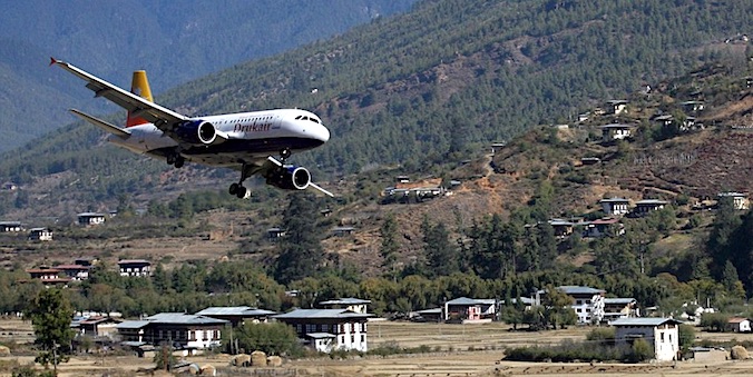
The flight to Paro (Bhutan) takes less than 2,5 h and, in clear weather, affords wonderful views of the Himalayas, including Mt. Everest (8848m) and Kangchenjunga (8568m). At the airport our guide and driver await you outside the airport, and will take you to Thimphu, the capital. On this short drive, you'll get a first glimpse of Bhutan's forests and rustic, half-timbered houses. Altitude 2350m. a:hover {color: #1146a9; background-color: transparent; text-decoration: underline; } -
Day 2: In Thimphu
You have the whole day to explore Thimphu. Besides the many options listed in the highlights below, you can visit the archery range and the animal park with the takin, the national animal of Bhutan. Or you can walk to a nearby monastery in the woods with beautiful views. Altitude 2350m. -
Day 3: Thimphu - Haa
We return in the direction of Paro but halfway veer off onto a much less traveled, very scenic road that leads to Haa. Altitude 2350 → 2670m. -
Day 4: In Haa
Today you’ll visit Lhakhang Kharpo, the largest temple in the area, and take several short walks in the countryside, visiting rustic villages and climb up to small, hidden monasteries. Altitude 2670m. -
Day 5: Haa - Paro
First we drive up to the Chele La (3988m) with fantastic views of the Himalayas. Then we hike down to a nunnery, set dramatically at the foot of a steep cliff, before descending to Paro by car. In the afternoon we explore Paro. Altitude 2670 → 2250m. -
Day 6: in Paro, walk to Tigersnest
Today you do the well-known hike to legendary Taktsang Goemba, better known as Tiger’s Nest. It is 2.5 h walking up and 1.5 h down, but the magical little temple is worth it. Altitude 2250 → 3120 → 2250m. -
Day 7: Paro - Drugyel Dzong - Shana (2 h)
The start of the 7-day trek used to be at Drugyel Dzong, one hour drive from Paro. As there is a dirt road now to the first trekking camp, most trekkers prefer to be dropped there. At the camp the trekking crew awaits you (cook & helper, horseman with packhorses). Altitude 2250 → 2870m. -
Day 8: Trekking Shana - Soi Thangthagkha (7 - 8 h)
The path climbs gradually up along the Paro river through forests of pine, oak and spruce and later on rhododendron. A side-trail once functioned as an important trade route to Tibet. Altitude: 2870 → 3630m. -
Day 9: Trekking Soi Thangthangkha - Jangothang (6 - 7 h)
Today’s climb leads along winter shepherd houses, perhaps also yak herds, and above the tree line wonderful views of the snowy Himalayas. Today’s campsite, at the foot of Mr. Jhomolhari (7314m) is one of the most beautiful in the Bhutanese Himalayas. Altitude 3630 → 4090m. -
Day 10: In Jangothang
Today is a day of acclimatization and rest. But you can also take one out of three walks: to a ridge with good views of Jichu Drake (6989m), towards Jhomolhari or further along the main valley. Altitude 4090m. -
Day 11: Trekking Jangothang - Nye La - Lingshi (7 - 8 h)
Today's first ridge offers breathtaking views of Jomolhari, Jichu Drake and Tserimgang. Then follows a climb to Nyele La (4700m) with more panoramic views of peaks and Lingshi Dzong on the descent. Altitude: 4090 → 4700 → 4000m. -
Day 12: Trekking Lingshi - Chebisa (5 - 6 h)
During this relaxed walking day you can choose for a detour up to Lingshi Dzong (4220m), a charming monastic fortress with great views. You will pass the villages of Lingshi and of Goyul, with its clustered houses, and reach camp with a beautiful nearby waterfall. Altitude: 4000 → 4220 → 3880m. -
Day 13: Trekking Chebisa - Gobu La - Somuthang (8 - 9 h)
During the long ascent to Gobu La (4410m) through wide pastureland with yaks, there is a great chance to spot large herds of blue sheep. After a number of ups and downs you reach the campsite at Shomuthang. Altitude: 3880 → 4410 → 3980 → 4220m. -
Day 14: Trekking Shomuthang - Jhari La - Robluthang (6 - 7 h)
After a two hour climb you will reach Jhari La (4750m) with wonderful views of snowy Gangchhenta (6840m) and - weather permitting – the peaks of Tserim Kang and Jomolhari. Camp is in a beautiful remote valley, the summer home for herds of takin, the Bhutanese National Animal. Altitude: 4220 → 4750m → 4160m. -
Day 15: Trekking Robluthang – Sinche La - Limithang (6 - 7 h)
The climb of Sinche La (5005m) takes about 3,5 hours; the last part is rather steep. After the pass you will see impressive end and side moraines and a glacial lake. The peak of Gangchenta towers above the campsite, which is reached after crossing a river. Altitude: 4160 → 5005 → 4140m. -
Day 16: Trekking Lingmithang - Laya (4 - 5 h)
Today you walk downhill along a narrow, winding river valley all the way to Laya village, at the end through dense forests. The village offers spectacular views of Mt. Gangchenta and Mt. Masagang. Altitude: 4140 → 3840m. -
Day 17: Trekking Laya - Rhodophu (6 - 8 h)
A day spent on recuperating from the trek and prepare yourself for the rest of this challenging but spectacular trip. Laya is a great place to do this, just for the great views and extraordinary inhabitants. Altitude: 3850m. -
Day 18: Trekking Laya - Rhodophu (6 - 8 h)
We descend to an army camp and follow the river till the turn off to Rhoduphu. The climb continues through rhododendron bushes to the river camp. Altitude: 3840 → 4160m. -
Day 19: Rhoduphu – Tsoma La - Narethang (5 - 6 h)
Soon the steady climb begins via a high open valley to Tsomo La (4900m), which offers a superb view of Lunana, Mt Jomolhari and Jichu Drake. You then cross a flat, barren plateau. The campsite is towered by the peak of Gangla Karchung (6395m). Altitude: 4160 → 5000 → 4900m. -
Day 20: Trekking Narethang - Gangla Karchung La - Tarina (5 - 6 h)
Climb to Gangla Karchung La (5120m) and enjoy breathtaking views of peaks like Jekangphu Gang (7100m), Tsenda Kang and Teri Gang (7300m). Descend and look down on a massive glacier tumbling down from Teri Kang to a turquoise lake. A long descent through thick rhododendron brings you to Tarina valley. Altitude: 4900 → 5120 → 3970m. -
Day 21: Tarina - Woche (6 - 7 h)
The trail follows the upper ridges of the Pho Chhu (chuu = river), leads through conifer forests and passes some impressive waterfalls. After a climb over a ridge you descend to Woche, the first hamlet in the Lunana region. Altitude: 3970 → 3910m -
Day 22: Woche - Woche - Keche La - Lhedi (6 - 7 h)
First you cross juniper and fir forests, later hododendron bushes. Climb up to Keche La (4650m), and descend to a village with a stunning view of Table Mountain (7100m). Follow the river till Lhedi village. Altitude: 3910 → 4650 → 3700m. -
Day 23: Lhedi - Thanza (7 - 8 h)
You pass through the small village of Chozo, which has a dzong still in use, and eventually reach Thanza. The Table Mountain forms a formidable 3000m high wall of snow and ice behind the village. Camp at Thanza or nearby Thoencha. Altitude: 3700 → 4150m. -
Day 24: Rest day at Thanza
Experience village life or climb the ridge for fascinating views. The crew will be busy arranging new yaks, as the yaks from Laya will not go any further. Altitude: 4150m. -
Day 25: Thanza - Danji (3 - 4 h)
The trail climbs up to a large boulder with excellent views of the villages of Thanza, Thoencha and Choso. Then follows a relatively flat section. From the excellent campsite near yak herders’ huts you have a great chance to spot some blue sheep. Altitude: 4150 → 4230m. -
Day 26: Danji - Jaze La - Tshochena (5 - 6 h)
After a long climb you reach Jaze La (5150m) with a spectacular panoramic view. Descend between snow-covered peaks and some small lakes to the campsite near the blue-green Tshochena Lake. Altitude: 4230 → 5150 → 4970m. -
Day 27: Tshochena - Loju La - Jichu Dramo (4 - 5 h)
First you climb a ridge, again with spectacular views, then you go up and down through a landscape with small hills and a glacial lake and climb up to the Loju La (5140m). After crossing a saddle you enter a wide glacial valley and descend to Jichu Dramo. Altitude: 4970 → 5140 → 5050m. -
Day 28: Jichu Dramo - Rinchen Zoe La - Chukarpo (5 - 6 h)
The ascent of Rinchen Zoe La (5320m), the highest pass on this route, is rewarded with spectacular mountain scenery, including views of Gangkhar Puensum (7570m) and Rinchen Zoe Peak (5650m) towering above the pass. You descend into a wide valley and go steeply down to the Thamphe Chhu with the first real trees since Lhedi. Hours later you reach Chukarpo. Altitude: 5050 → 5320 → 4600m. -
Day 29: Chukarpo - Tampe Tsho (5 - 6 h)
The descent continues along the river to the yak herder huts at Gala Pang Chhu. From here the trail climbs steeply towards Thampe Tsho, a beautiful clear turquoise lake. Altitude: 4600 → 4300m. -
Day 30: Tampe Tsho - Thampe La - Maurothang (5 h)
You climb steeply to the Thampe La (4600m) with a good chance to spot some blue sheep. Then the path descends to the sacred lake Om Thso and a waterfall, and continues steeply down to the Nikka Chhu. Cross the mixed forest and reach a large clearing with a few yak herder huts. Altitude: 4300 → 4600 → 3510m. -
Day 31: Maurothang - Sephu - Punakha (5 - 6 h walking, 4 h driving)
The path follows the Nikka Chhu to reach a large grassy area overlooking the village of Sephu, the end point of this fabulous trek. From here, you will be taken to Punakha. Altitude: 3510 → 2600 → 1400m. -
Day 32: Punakha – Paro (3.5 h)
In the morning we visit the dzong of Punkaha, arguably the most beautiful one in Bhutan, and other sites if you are interested. After lunch we drive back to Paro. Altitude: 1400 → 2250m. -
Day 33: Paro ✈︎ Delhi
Early morning you'll be transferred to the airport for your return flight to Delhi, hopefully again with wonderful views of the Himalayas. If you have asked us to arrange accommodation and transfers in Delhi you will be picked up from the airport by our driver.
HIGHLIGHTS OF THIS TOUR
Flight to Paro
Paro
Thimphu
Sights of Thimphu
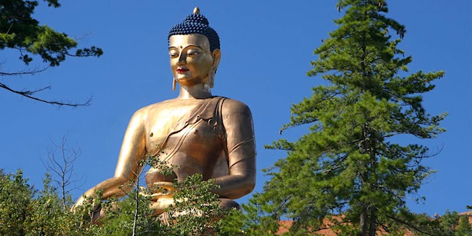
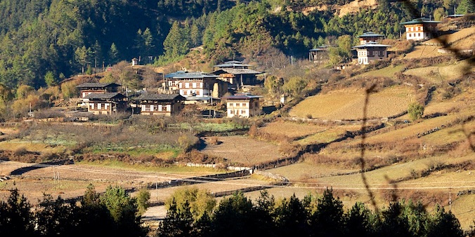
Road Chuzom - HAA
HAA
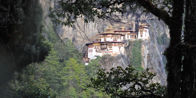
TakTsang Goemba (Tigersnest)
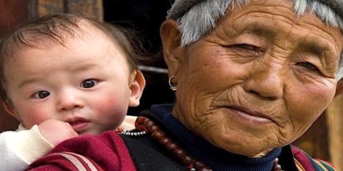
The People of Laya
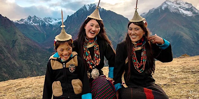
The people inhabiting the area around Laya, in Bhutanese, are called Layap. Their language, Layakha, is a Tibeto-Burman language, just as Dzongka, the official language of Bhutan. Their dress is a mix of Bhutanese traditional dress and the Tibetan costume. Men wear the Bhutanese gho, aan ankle-length cotton, silk or linen garment, while women wear long black woolen jackets, also ankle-length, with trousers under it. Traditionally, the Layap are semi-nomadic, taking their herds of yak and sheep onto the high Himalayan pastures in the summer, while braving the winter in their village at 3850m. As agriculture is constrained by the altitude, food items were partly obtained by barter with lower living villagers. Collecting Cordyceps, a highly valued fungus with medicinal properties, adds to their cash income, as well as portering for trekkers with their yaks.
