MOUNTAINS and FESTIVALS of NAGALAND and MANIPUR
Tour - 21 days
About NAGALAND & MANIPUR
Nagaland is wedged between Assam in the west and Myanmar (Burma) in the east. It is about half as large as the Netherlands and, with around 2 million inhabitants, relatively thinly populated. Nagaland is quite mountainous, the highest mountain reaching 3840m (Mt. Saramati). But most of the state is between 500 and 2000m, and thus endowed with a climate in which virtually anything will grow. The main crops are rice (especially mountain rice), corn, millet, pulses, tobacco, oil seeds such as mustard, sugarcane, potato, and bamboo.
A significant part of the Nagas still live of shifting cultivation. This is a form of agriculture wherein every so many years a new piece of forest is burnt down, then tilled for some time till the soil is exhausted, and left for another piece of land. The government is trying to discourage this highly unsustainable form of farming, and encourage alternatives, such as orange and pineapple cultivation.
Read more…Read lessThe people of Nagaland belong to the Burmese-Tibetan ‘race,’ probably originating from Tibet, perhaps with influx from Southeast Asia. They are believed to have settled around the year 1000 in present day Nagaland. Although he Nagas never had their own state, they were considered a culturally and geographically distinct entity by neighbouring countries.
One of the causes of this lack of statehood was the habit of the Naga tribes to continuously wage wars between them. In addition, the Nagas had the curious habit of head hunting. The heads and scalps were cherished as trophies and can still be seen in the villages. Contact with Christianity has eventually made them abandon the practice, but not before the early fifties. Today the war dances of the Nagas, performed at festivals, are a major draw for tourists.
There are 18 different tribes, each with its own distinct customs, dialect and clothing. But the Nagas are united in their cultural traditions and customs, religion – today, almost all Nagas are Christians – and the use of Nagamese – a lingua franca that is a mix of Naga and Assamese.
Manipur lies south and east of Nagaland and borders Myanmar (Burma). The state is also mountainous and thinly populated. The economy is mainly agricultural, largely self-sufficient (little or no export) and also relies on hydroelectric power generation. The inhabitants belong to different groups, such as the Meitei, the Kuki, Naga, and Pangal. All these peoples speak a Sino-Tibetan language. Although Manipur has been at the crossroads between South Asia (India) and Southeast Asia for at least 2500 years, today, it is the least visited state of India (by tourists).
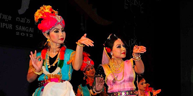
Read more…Read lessIn sharp contrast to Nagaland, Manipur was already about 2000 years a political entity. Before joining India in 1949, it was an independent, so-called princely state. The main ethnic group in Manipur are the Meitei (53% of the population). These are predominantly Hindu, and their language Meeteilon (Manipuri) is also the official language of the state. Within India, the state of Manipur is known for its good polo players and polo horses, but also for its traditional dances. These are considered to be part of the official classical dances of India.
Region
Assam & Arunachal Pradesh
(India)
Best Time
Feb-April &
Oct-Dec
No. Of Days
21 days, 3 days trekking
Trip Character
Jeep tour with walks & short trek
Sleeping Altitude
65 - 1630 m
Trek Character
Camping trek
Level: 2
Price
INR XXX/ $ XXX
ABOUT THIS TOUR
The far-eastern states of Nagaland and Manipur are due outside the tourist circuits. Manipur is even India’s least visited state. Thať’s not because there is nothing to see. The mountains are lush green thanks to abundance of rain and harbor some very fine subtropical forests and supreme mountain vistas.
The Nagas, though once upon a time fierceful warriors and even head-hunters, a tradition that lives on in a peaceful manner in their culture, are known for their hospitality. Originally adhering to animistic beliefs, these days most people of Nagaland and Manipur have been converted to Christianity, though in Manipur Hinduism has rooted as well.
During festivals the vibrant ancient cultures of the Nagas and Manipuris come to live in war and harvest dances performed in utterly exotic and colourful costumes. Each of the 45 tribes of Nagaland and Manipur has its own different traditional wear and dances.
On this trip we visit two of the most colourful and well-organised festivals of the Northeast: the well-known Hornbill Festival in Kohima (Nagaland) and the much less know Sangai Festival in Imphal (Manipur). The latter is named after a rare species of marsh-dwelling deer found only in Manipur.
In between the festivals we visit remote villages and do a number of walks that will get you well of the beaten track. This includes a three-day trek up to Mt. Saramati, Nagaland’s tallest mountain (3841) from where you get good views of neighbouring Myanmar.
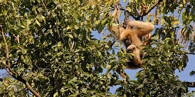
The tour ends at Jorhat in Assam, where we visit the small but beautiful Gibbon Sanctuary, a wildlife reserve best known for its rar and endangered Hoolock Gibbons, an ape species native to Assam and Bhutan. From Jorhat you fly back to Delhi.YOUR custom-made TRIP
The tour described here, as well as the other ones on our website, are mainly meant as suggestions. We would be happy to offer you a travel proposal that fully meets your personal demands and expectations. That means that you choose where you want to go, what level of accommodation and type of transport you want and what activities you prefer.
Please let yourself be inspired by this and other trips on our website and then drop us a line (or call us) to explain your travel wishes. We will be happy to help you put together the perfect trip. You can reach us over e-mail, Messenger, Whatsapp or mobile phone.
EXTENSIONS & VARIATIONS
Apart from the tour as described here, you could consider the following add-ons and changes:
- Do a more challenging trek instead of the Mehao Lake and Namdapha treks. For instance, the Baily Trek.
- If trekking is not your cup of tea we can show you some of the beautiful mountain forests, off-road villages and majestic views of the Himalayas on day walks
ITINERARY
-
.fa-info {color: #1146a9;}.fa-info:hover {color: #387dff;}Day 1: Delhi / Kolkata ✈︎ Manipur
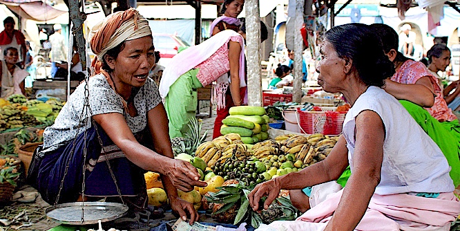
From Delhi you arrive by flight at Imphal, the capital of Manipur. You will be received by your guide and driver and taken to your hotel. Later you can visit Ima Market (Mothers Market) where Manipuri women sell all kinds of wares. Altitude 785m. -
Day 2: In and around Imphal
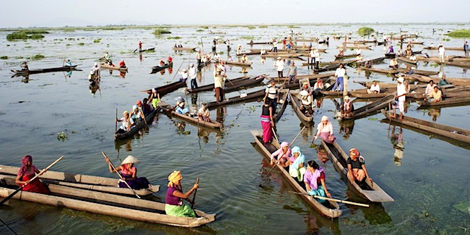
Today you visit the famous floating lake of Loktak, amazingly formed larest lake of North East. Next will visit the nearby Keibul Lamjao national park where the rare ‘Sangai’ live. These deer forage on the floating vegetation and they are called dancing deer because of this manouvring act. The festival you are attending in Imphal is named after this animal. Altitude 790m. -
Day 3: In Imphal, attending the Sangai Festigval
In the morning you can visit the popular Shree Govindaji Temple, dedicated to Lord Krishna, WW II cemeteries of both the allied and Japanese forces, and Kangla Fort. After this, you’ll attend the Sangai Festival. Altitude 785m. -
Day 4: Imphal - Ukhrul (3 h)
In the morning we drive to Ukhrul, northeast of Imphal. After lunch at the hotel we’ll explore this small town on foot, visiting the local market, and make a short walk through rural areas outside town. Altitude 785 → 1880m. -
Day 5: In Ukhrul, walk to Siroy Peak
After a short drive to a small village called Khangkhui Khullen, we’ll walk up to Siroy Peak (2835 m). It is a long day walk (23 kms up and down) but you can turn around half way. Even then you’ll enjoy good views of Myanmar. Altitude 1880 → 1850 → 2835 → 1850 → 1880m . -
Day 6: In and around Ukhrul
Today we’ll visit some villages in the surroundings of Ukhrul inhabited by Tangkhul Naga, the main inhabitants of the area. Altitude 1880m.. -
Day 7: Ukhrul - Imphal(3 h)
Today you return to Imphal. Altitude 1880 → 790m. -
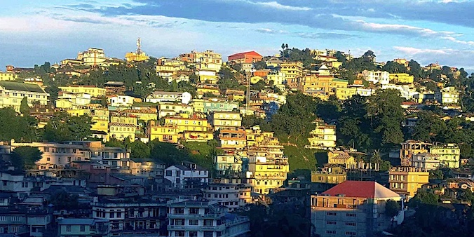
Day 8: Imphal - Kohima (5 - 6 h)
We drive north to Kohima crossing the Manipur-Nagaland border at Mao, In the afternoon we explore the market of Kohima. Altitude 785 → 1440m. -
Day 9: In Kohima / attending the Hornbill Festival
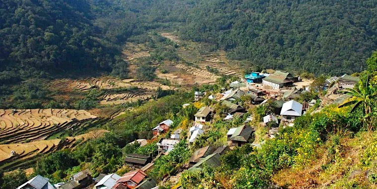
If you are in Kohima during one of the first ten days of December, today you’ll witness the spectacular Hornbill Festival. Else, we’ll take you to picturesque Khonoma village. Altitude 1440m. -
Day 10: Kohima - Khonoma - Kohima (2 h)
In the morning visit beautifully green Khonoma village. This village is picturesque, very well preserved and its inhabitants have decided to declare the forest area near the village a protected bird sanctuary. If the Hornbill Festival is on. you can spend the afternoon at the festival. Altitude 1440 → 1620 → 1440m. -
Day 11: Kohima – Meluri (6 - 7 hr)
Today, we are heading east towards Meluri. Small part of the way will be through northern Manipur. Late afternoon you can take a walk around Meluri, and maybe chance upon Chakhesang tribesmen wearing traditional attire. Overnight at a simple government lodge. Altitude 1440 → 1630m. -
Day 12: Meluri - Pungro (4 hr)
Driving northeast we reach Pungro town. The area is inhabited by people of the Yimchunger and Sumi tribes, both Naga tribes. Overnight at the New Tourist Lodge. Altitude 1440 → 1620 → 1440m. -
Day 13: Pungro – Thanamir (5 -6 h)
Starting early today, after a short distance we stop at the village of Salumi where a short walk takes us to a large natural cave. Driving on we reach the settlement of Thanamir (2050 m) where we disembark and our trek starts. We can stretch our legs while the porters pitch our tents. Overnight in tents. Altitude 1440 → 1620 → 1440m. -
Day 14: TREK Thanamir – Water Point (10 km/ 3 - 4 hr walking)
From Thanamir we gradually trek through half-open country of lush green fields, pastures and remnant forests to a place called ‘Water Point’ (2700 m) negotiating with a trek of roughly 5 hours. Overnight in tents. Altitude 1440 → 1620 → 1440m. -
Day 15: TREK Water Point – Mt. Saramati – Water Point (20 km/ 7 hr walking)
Today you’ll climb Mt Saramati (3841 m) and afterwards return to camp at Water Point. Distance is roughly 10 km, altitude gain almost 1150m. Mt. Saramati is a ’walkable mountain.’ Most of the climb is gradual but some sections are steep. On a clear day you get fascinating views of Nagaland and the ‘Myanmar section’ of Nagaland. Overnight in tents. Altitude 1440 → 1620 → 1440m. -
Day 16: TREK Water Point – Thanamir & car to Pungro (10 km/ 3 hr walking & 4 hr drive)
We walk down to Thanamir, where we board the vehicles and drive back to Pungro. Altitude 1440 → 1620 → 1440m. -
Day 17: Pungro - Tuensang (5 - 6 hr)
Today’s drive is through villages of the Yimchunger and Chang tribes. We will stop at some of their villages and feel their way of life. Overnight at local government lodge. Altitude 450 → 1375m -
Day 18: Tuensang - Mokokchung (4 hr)
In the morning we will visit a Chang village near Tuensang and then proceed to Mokokchung, visiting another Chang village on the way. Overnight at Mokokchung Tourist Lodge. Altitude 1370 → 1325m. -
Day 19: Around Mokokchung (4 hr)
After a number of ‘driving days, today, there will be some walking again. We’ll visit Mopungchuket village, where you can see the traditional morong (community building where the young men sleep) and then proceed to climb a watch tower. In the afternoon we visit the village of Longkhum, an Ao Naga bastion during the tribal wars era which boasts of many head hunting relics. If you are in Mokokchung during the first three days of May you can witness the Moatsu Festival. Altitude 1325m. -
Day 20: Mokokchung – Jorhat (4 hr)
We descend to Jorhat in Assam. On the way we visit Gibbon Sanctuary, a wildlife reserve with a large population of Hoolock gibbonsan ape species endemic to Assam and Bhutan. While exploring the jungle on foot with a forest guard we will try to spot other animals available there like great and pied hornbill, giant squirrel, and even wild elephants. Altitude 1325 → 65m. -
Day 21: Jorhat ✈︎ Delhi
Early morning you are being transferred to Jorhat Airport for the flight to New Delhi. It depends on the timing of your international flight whether you will need an overnight stay in Delhi. In the latter case we can arrange this for you. Altitude 65 → 220m.
HIGHLIGHTS OF THIS TOUR
Manipur Culture
Imphal
Loktak Lake

SANGAI FESTIVAL
Walk to Siroi Peak

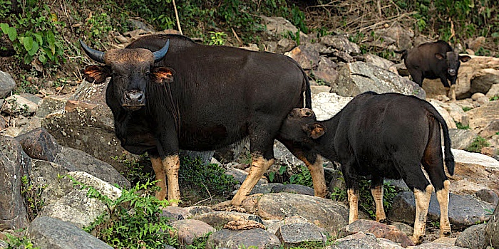
The Mithun
Kohima
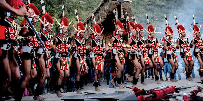
HORNBILL FESTIVAL
Khonoma

MELURI
TREK to MOUNT SARAMATI


TUENSANG
MOKOKCHUNG
Mokokchung is the centre of a district of about 1615 km2 located south of Jorhat in Assam. The area is mainly inhabited by the Ao Nagas, with a population of about 230,000 people one of the most important Naga tribes. The Aos were the first among the Nagas to convert to Christianity. This began in 1872, when the American Baptist missionary Edwin W. Clark visited the area. Early exposure to Western influences also brought Western education and changes in agricultural practices and lifestyle which other Nagas adopted much later. However, the Aos’ main form of agriculture is still the old slash and burn (also called jhum or shifting cultivation). Wet rice, millet, maize and Job’s tears (Coix seeds) are the main grains, as well as vegetables such as tomatoes, cucumbers, chilis, pumpkins and various ‘green leaves.’


Moatsu FESTIVAL
Gibbon Sanctuary
Less than an hour’s drive from Jorhat is the Gibbon Sanctuary. This is a relatively small but beautiful protected area where the very rare Hoolock gibbons live, along with wild elephants and many species of forest birds. The Hoolock gibbons belongs to the great apes and only occurs in Assam and Bhutan. Chances to see the Hoolocks here, as they swing from branch to branch, are very good, especially early morning. You can visit the park on foot, accompanied by a park ranger. You’ll see many birds as well, and if you are lucky, a heard of wild elephants will cross your path!