
The historic Bailey Trail – Trek to Tawang
Tour - 15 days/ 7-day trek
About Arunachal Pradesh
Arunachal Pradesh is by far the most mountainous state in the northeast of India. It is sandwiched between Bhutan in the west and Myanmar in the east and shares its entire northern border with Tibet/China. This border is formed by the highest glacier-covered peaks of the eastern Himalayas, a very difficult area to reach.
At lower altitudes, between 1000 and 3000m, the state is endowed with dense temperate forest and the most extensive subtropical jungle of India. Here, the majority of Arunachal’s diverse population lives, divided over many different ethnic groups.
Read more…Read less
There are at least 26 different tribes, depending on who’s counting. Each of these tribes has its own language, culture, form of agriculture, religion, costumes and customs. Most of them are originally hunter-gatherers who live off what the forest yields. Donyi-Polo, the Sun-Moon god, is more popular here than Shiva, Mohammed, Jesus or Buddha. The exact origin of these tribes is largely unknown but customs, language and looks point to East Asia and border areas of Tibet.
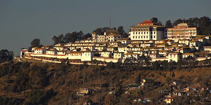
BUDDHIST ENCLAVESArunachal also has pockets of Buddhism. In the far east of the states there are some villages where one could imagine being in Myanmar or Thailand, as the same Hinayana (Theravada) form of Buddhism is followed here. Mahayana (‘Tibetan’) Buddhism is followed by the Memba of Mechuka (north of Along) and is especially predominant in the northwestern corner of the state, where Arunachal borders both Tibet/China and Bhutan. Here,the Sherdukphen and Monpa live. Their language and culture are very reminiscent of their neighbours across the border. Tawang, the main town in this area, is said to have the largest ‘Tibetan’ Buddhist monastery outside Tibet.
To reach this area, involves either 2.5 days of driving from Guwahati, whereby one crosses the 4170m high Sela Pass, or minimally seven days of trekking, crossing even higher passes. The latter is done on the tour described here.
Region
Arunachal Pradesh
(India)
Best Time
March-April &
Oct-Dec
No. Of Days
15 days, 7 days trek
Trip Character
Trekking tour
Sleeping Altitude
50 - 4200 m
Trek Character
Camping trek
Level: 3
Price
INR XXX/ $ XXX
ABOUT THIS TOUR
Trekking in Arunachal Pradesh is still really undeveloped. This trek follows, in part, the historic Bailey Trail, a reconnaissance of the Indo-Tibetan border done by Lt. Col. Bailey in 1911. However, it is by no means an established trekking route as not many outsiders follow it at present.
On this tour, you first travel from Delhi to Guwahati, the capital of Assam. From there, you travel along the tea centre of Tezpur upto the small town of Thembang in Arunachal Pradesh (2170m). Here, your trek along the historic Bailey Trail will start.
This trek leads you through several different altitude zones. On the first part, you will meet with a tropical environment and unknown tribes such as the Aka and Miji, who had never seen westerners until very recently. You walk over forest trails and open farmland, sometimes through dense primary (virgin) forest, and you regularly follow wild rivers.
Read more…Read less
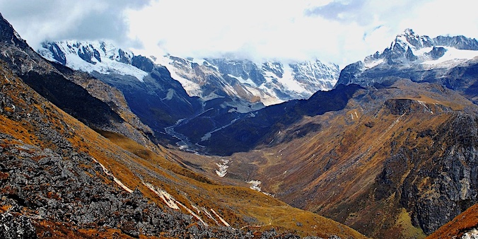
After the first days, you’ll reach higher elevations where inhabitation is sparse and the vegetation is moderate. You’ll walk through oak and mixed forests of rododendrons with conifers. In April the rododendrons should be blooming. Even higher, you’ll be crossing yak meadows and eventually come close to an altitude 5000 m. Here, you’ll have magnificent views of Himalayan peaks like the Gorichen (6500 meters) and Kangto (7090 m).
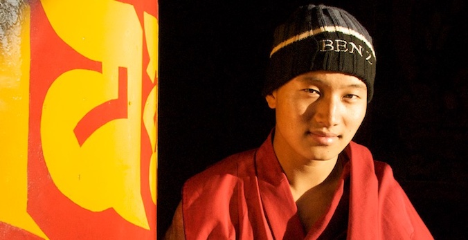
This is the home of the Monpa tribe, whose villages you’ll cross. The Monpa are of Tibetan descendence and follow the Lamaist form of Buddhism. The same people you’ll meet on your subsequent visit to Tawang and Tawang Monastery, said to be the largest Lamaist Buddhist monastery outside Tibet.
After completing the trek you come down to Tezpur again. You’ll spend two nights at nearby Nameri National Park. Here, you explore this magnificent park on foot and (if you like) by rafting.
YOUR custom-made TRIP
The tour described here, as well as the other ones on our website, are mainly meant as suggestions. We would be happy to offer you a travel proposal that fully meets your personal demands and expectations. That means that you choose where you want to go, what level of accommodation and type of transport you want and what activities you prefer.
Please let yourself be inspired by this and other trips on our website and then drop us a line (or call us) to explain your travel wishes. We will be happy to help you put together the perfect trip. You can reach us over e-mail, Messenger, Whatsapp or mobile phone.
EXTENSIONS & VARIATIONS
Apart from the tour as described here, you could consider the following add-ons and changes:
- Spend a few days at a tea estate in Tezpur, to fully unwind and relax before you start on the trek.
- If you’re interested in wildlife, consider adding a few days at Kaziranga National Park, home to a large population of Indian rhinos, wild buffalos, wil elephants, deer and almost 500 species of birds. It is only 4.5 hours drive from Guwahati or 3.5 hours drive from Tezpur/Nameri.
ITINERARY
-
.fa-info {color: #1146a9;}.fa-info:hover {color: #387dff;}Day 1: Delhi / Kolkata ✈︎ Guwahati & car to Tezpur
At Guwahati airport you’ll be greeted by our staff and then transferred to Tezpur at the northern edge of the Brahmaputra flood plain. You'll cross this magnificent river shortly after leaving Guwahati. Altitude 50m. -
Day 2: Tezpur - Thembang (5 - 6h)
After brief formalities at the AP-border, drive up-hill for almost 6 hours to Thembang, passing the town of Bomdila. Dramatic landscape change from plains to jungle-covered mountains. In Thembang the trekking staff (guide, cook and horsemen) will be waiting. Overnight in trekkers tent. Altitude 50 → 2350m. -
Day 3: Trekking Thembang - Tungri (5 -6 h)
The trek starts at Chander, not far from Thembang. The trail ascends gradually and the vegetation changes from subtropical to temperate forests with conifers and Rhododendrons (spectacularly blooming in April). Altitude 2350 → 3100m. -
Day 4: Trekking Tungri - Chang La (6h)
You get into more alpine area now. The trail rises and falls through beautiful forests interspersed with yak meadows where you ge breathtaking views. Altitude 3100 → 3600m. -
Day 5: Trekking Chang La - Potak (6 h)
The trail meanders along a river with crystal clear water. Approaching 4000m it will be getting quite a bit colder, especially if it is foggy. When the sun shines it will be pleasantly warm, though. The vast landscape gives you an awesome sense of space. Altitude 3600 → 4200m. -
Day 6: Trekking Potak - Je La - Lurtem (7 h)
Today’s walk has everything that makes a Himalayan trek so rewarding, such as beautiful turquoise mountain lakes and a pass (at 4715m) that rewards you for your efforts with magnificent views of the great Himalayan Range. Altitude 4200 → 4715 → 4200m. -
Day 7: Trekking Lurtem - Mago (6 h)
Descending to the village of Mago, you pass through beautiful virgin forest. Mago’s hot springs will offer welcome relief after so many days in the wilderness, and the tiny Buddhist monastery is worth a peek. Altitude 4200 → 3615m. -
Day 8: Trekking Mago - New Mealing (6 h)
At Mago the horse men are replaced by horsemen from New Mealing. A longish but scenic route awaits you, with beautiful forests, enormous vertical rock faces and a roaring river with crystal clear water and countless waterfalls. Altitude 3615 → 2640m. -
Day 9: New Mealing - road & drive to Tawang (1.5 h walking, 1.5 h driving)
We continue walking down along the beautiful river. After a while we will see first signs of road construction and soon after the car that is awaiting us. Near Jang you can see a gigantic waterfall that plunges hundreds of meters down. From here it is about drive 45 km to Tawang. Altitude 2640 → 3000m. -
Day 10 & 11: In Tawang
Two days will be spent exploring Tawang and its surroundings. Beside the monastery there are several smaller gompa's in the area. We can also visit the Stupa of Gorsam and Urgelling, the birthplace of the 6th Dalai Lama, as well as the border area where the present Dalai Lama entered India after fleeing Tibet in 1959. Altitude 3000m. -
Day 12: Tawang - Bomdila (6 - 7 h)
Today you drive south to Bomdilla. On the way you will be crossing the Sela Pass, at 4170 m the highest motorable pass in the Northeast. At Bomdila you can do an evening visit to Bomdilla town and its Buddhist monasteries. Altitude 3000 → 4170 → 2415m. -
Day 13: Bomdilla - Nameri N.P. (4 - 5 h)
Going further south you’ll reach the foothills of the Himalayas near Tezpur. Here you’ll veer east onto a small road that leads to Namri National park. Altitude 2415 → 100m. -
Day 14: In Nameri N.P.
Today you'll visit the park twice on foot with a park ranger. Many rare birds live in Nameri, including the extremely endangered white-winged wood duck. On the walks you have the chance to encounter wild elephants, a thrilling experience. Altitude 100m. -
Day 15: Nameri - Guwahati ✈︎ Delhi
Today you'll return to Guwahati, where you can catch a flight to Delhi. It depends on the timing of your international flight whether you will need an overnight stay in Delhi. In the latter case we can arrange this for you. Altitude 100 → 75m.
HIGHLIGHTS OF THIS TOUR
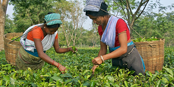
TezpuR Tea Gardens
The Bailey Trail
The Bailey trek follows old trails that connect small isolated villages in the northwest of Arunachal Pradesh. It is named after Lt. Col. F.M. Bailey. In 1911 and 1912 he was sent by the British administration to explore and establish the border with Tibet, together with a surveyor. As finding access from the western part of the North East Frontier Agency (NEFA), as Arunachal Pradesh was called a the time, was difficult, they traveled to the eastern side and entered Tibet where the Brahmaputra enters India. From the Tibetan side (which is much higher) they were able to to explore the highest peaks of the Himalayan Range, thus establishing the so-called MacMahon Line which has served as the border since 1914 (accepted by Tibet but later contested by China). They crossed the Tulung La into India and after reaching Mago followed what we today call the Bailey Trail to Thembang.
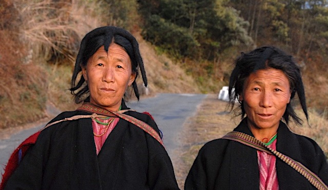
The Monpa people of Tawang
Tawang
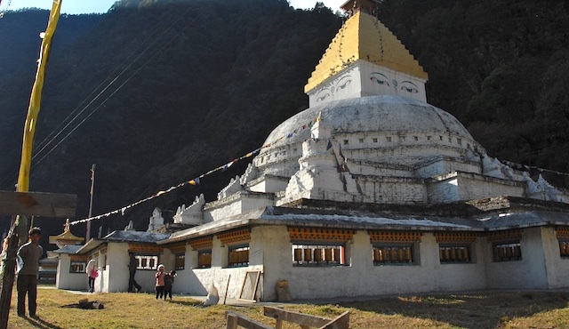
Surroundings of Tawang
Bomdila
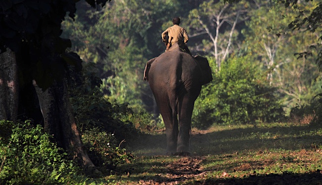
Nameri National park
Nameri is a beautiful national park located between the Jia Bhorelli river and the foothills of the eastern Himalayas. The vegetation consists of moist deciduous forests with epiphytes and lianas, sections of cane and bamboo, and some open grasslands along the rivers. The park is very popular with bird enthusiasts, but also non-birders will greatly enjoy its pleasant atmosphere. Birds to look for are merganser, Pallas’s fish eagle, lapwings, cormorants, ruddy shell duck, kingfishers and perhaps the elusive white-winged wood duck and the great Indian Hornbill. In 2000 part of the park was declared a tiger reserve. The best accommodation here is Nameri Eco Camp. Here, you sleep in comfortable ‘safari tents’ under thatched roofs with attached bathrooms and in lush forest surroundings.