BRAHMATAL and ROOPKUND TREK
Tour - 9 days/ 7 days trekking
About UTTARAKHAND
Uttarakhand is a state blessed with an enormous diversity of cultures and landscapes. Just like Himachal Pradesh, Sikkim, Bhutan and Arunachal Pradesh, it spans the whole altitudinal range from steamy jungle where tigers and wild elephants roam to some of the highest peaks of the Himalayas. One of them is Nanda Devi (7816 m, 25,636 ft), the highest mountain that lies fully in India.
TREKKERS’ PARADISEThe higher reaches of the Uttarakhand Himalayas are a mecca for trekkers. You can follow the herders up to the high bughyals (alpine meadows) and trek up to passes that in the old days gave access to Tibet. They reward you with some of the best glacial vistas in the Himalayas. Although the number of Indian trekkers is increasing, these areas still don’t get that many visitors as the much more known treks of Ladakh and Himachal Pradesh.
Read more…Read less
Wildlife enthusiasts find a treasure trove of biodiversity here, partly protected in national parks and wildlife reserves throughout the state. Most notably, Jim Corbett National Park and Nanda Devi & Valley of Flowers National Park. Jim Corbett National Park is named after A famous British hunter-turned-conservationist. It is well known and popular as it is one of the tiger parks in India that is easiest to reach from Delhi. Apart from being home to a wide array of mammals, birds and plant life, it has very appealing landscapes and a well-laid out infrastructure of jeep trails. Nanda Devi & Valley of Flowers National Parks are two formerly separated but now joined protected areas lying almost completely at or higher than 3500m (11.500 ft). They can be explored only on foot.
HINDU PILGRIMAGETo Hindus – who make up 83% of the state’s population – the higher reaches of Uttarakhand are known as Dev Bhoomi – the abode of the gods. This is not just folklore, as present day Hindu culture finds many of its roots in this area. It is believed that the sage Vyasa scripted the Hindu epic Mahabharata here. In the Middle Ages, the Hindu kingdoms of Garwhal and Kumaon made up the western and eastern part of the present day state, respectively.
Millions flock every year to the many pilgrim sites that the state harbors. Easily accessible places like Rishikesh, Haridwar are not only popular with Hindu pilgrims but also host numerous ashrams and yoga schools that cater mainly to foreign visitors. Much higher up, you can witness die-hard Hindu pilgrims and saddhus dipping themselves in ice-cold waters where Mother Ganga (Ganges) emerges from the mouth of a glacier.
BREATHTAKING VIEWS, COZY RETREATSTraveling by car, you may experience Uttarakhand as a never-ending series of curves and switchbacks, but after each of these bends new views and sights await you. The mountains are covered in forests and green fields and especially in the winter months you get breathtaking views of the snow-clad Himalayas on the border with Tibet (China). Uttarakhand counts numerous so-called hill stations, towns situated at medium elevation levels that have been welcoming tourist since the British era. These hill stations are popular with domestic tourists, but have a lot to offer to ‘foreigners’ as well. In and around them, you can find (with some effort) hidden lodges, boutique hotels and family-run retreats with a high degree of the ‘Hotel California factor’: you can check in any time, but you may never want to leave.
Region
Kumaon (Uttarakhand,
India)
Best Time
Sept - May
No. Of Days
9 days, 7 days trek
Trip Character
Trekking tour
Sleeping Altitude
1200 - 3460 m
Trek Character
Camping trek
Level: 2-3
Price
INR XXX/ $ XXX
ABOUT THIS TOUR
On this tour, we combine the lesser known Brahmatal trek with the well-known Roopkund trek. That is, in the spring and summer. In the winter, we only take you to Brahmatal, as deep snow will make the going tough higher up. On both trek variants you will enjoy awesome views of snow-clad mountains and glaciated peaks.
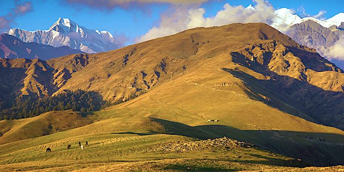
Located at a height of 3230 meters in the Garhwal ranges in Chamoli district (Uttarakhand), Brahmatal is nestled in the lap of the Trishul Massif (7120m), and surrounded by beautiful snow-clad peaks. Roopkund is even higher (4535m) and the area in between is dominated by extensive alpine grasslands (called bughyals), dense conifer forests and beautiful mixed forests of oak, rhododendron and deodar (cedar), and mountain ridges that offer ever surprising vistas. It was on the trail to Roopkund that the famous explorer Eric Shipton once said: “A vision of such beauty is worth a world of striving.”
The Brahmatal and Roopkund trek starts 15 km from Tharali, a small village on the banks of Pindar river. The winter trek to Brahmatal and back takes about 5 days, excluding all travel. The Brahmatal and Roopkund trek (spring and summer) between 7 and 10 days, depending on the route.
YOUR custom-made TRIP
The tour described here, as well as the other ones on our website, are mainly meant as suggestions. We would be happy to offer you a travel proposal that fully meets your personal demands and expectations. That means that you choose where you want to go, what level of accommodation and type of transport you want and what activities you prefer.
Please let yourself be inspired by this and other trips on our website and then drop us a line (or call us) to explain your travel wishes. We will be happy to help you put together the perfect trip. You can reach us over e-mail, Messenger, Whatsapp or mobile phone.
EXTENSIONS & VARIATIONS
Apart from the tour as described here, you could consider the following add-ons and changes:
- Trek further up along the Roopkund Trail after joining with it to see this famous lake. This takes another four days.
- Do a more challenging trek such as the Panpatia-col-trek.
- Visit the fascinating Jim Corbet National Park, home to tigers, wild elephants and a dazzling array of bird species.
- If trekking is not your cup of tea we can show you some of the beautiful mountain forests, off-road villages and majestic views of the Himalayas on day walks.
ITINERARY
-
.fa-info {color: #1146a9;}.fa-info:hover {color: #387dff;}Day 1: Delhi - Kathgodam - Tharali (5 h train ride, 195km/ 7 h drive)
Early morning transfer to the railway station where you board the Shatabdi Express to Kathgodam. There, our driver and guide will pick you up. A 7 hour journey into the Himalayas will take you to Tharali, a small village at 1200m at the foot of the Himalayan Range. Altitude 215 → 550 → 1200m. -
Day 2: Tharali - Ratgaon -Bekhaltal (6km/ 2 h walking)
A short drive taks you to the trailhead at Ratgaon (2450m). The first part of the trek is walking across lush green meadows, after which the trail enters dense forest. The climbing is gradual. Overnight is at an idyllic campsite just below a small lake called Bekhaltal. Altitude 1200 → 2450 → 2900m. -
Day 3: Bekhatal - Brahmatal (6 h walking)
A somewhat steep climb of about 2 km takes you to a place called Tailati. After this, the trail levels out, with small ups and downs. Finally, a short descend leads to Brahmatal, a beautiful lake. Mount Nanda Ghunti (6309) can be seen in the background. Overnight in camp. Altitude 2900 → 3200m. -
Day 4: Climbing nearby peak (3-8 h walking)
Depending on the snow conditions, we climb a nearby peak at 3525m, from which we ge very good views of the peaks Kamet, Trishul, Nandaghunti, Chaukhamba and many more. Or we continue to Jatropani Peak (4071m) from where views are even beter. Overnight at Brahmaptal. Altitude 3200 → 4071 → 3200m. -
Day 5: Brahmatal - ridge - Tilburi (8km/ 3 h)
In January/February you descend back to Ratgaon and Tharali. In March, you can continue the trek for another 5 days crossing over to the Rupkund Trek. Today, you will ascend the ridge eats of Brahmatal, from where you can have again magnificent views of the peaks. Your campsite, at Tilburi, is in a rhododendron forest. Altitude 3200 → 3500 → 3460m. -
Day 6: Tilburi- Kukinkhal Pass- Mindfara (
Today we will proceed to Kukinkhal which is a pass to Kanol valley. Mindfara is alpine meadow where camping is not allowed so we will camp beneath near the forest. Trek distance is about 8-9 kms a bit up and down. Altitude 3460 → 4000 → 3480m. -
Day 7: Visit Baluni Top
Another day exploring from camp. Today you climb up to Baluni Top, a viewpoint from where you get a magnificent view of Vanoti (5646), Tent Peak (5695), Tharkot (6099), Maiktoli (6803) and Panwalidwar (6663), among others. The trail is initially quite steep, later leads over a beautiful bugyal (alpine meadow). Overnight in camp. Altitude 3205 → 3815 → 3205m. -
Day 8: Ali Bugyal - Didna - Lohajung (13km, 4 h)
Descending through forests, you reach the small, traditional village of Didna. In case you want to take it easy, you can stay the night here in a homestay. Dropping further down to the valley bottom, you reach Lohajung, the startingpoint of the Roopkund trek and the endpoint of this one. Overnight in hotel or homestay. Altitude 3480 → 1970m. -
Day 9: Loharjung - Kathgodam - Delhi (7 h driving; 5h train)
After an early departure, our car will take you down to Kathgodam, where you’lll board the Shatabdi Express to Delhi (departure appr. 3:30 PM). Altitude 215 → 215 → 290m.
HIGHLIGHTS OF THIS TOUR
KUMAONI VILLAGES
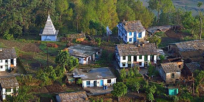
On you trip through Kumaon you will regularly see a small village of five to ten houses in the valley below you or on the slope across from the road. Most of them are not right on the road because that’s where concrete structures generally take over. But there are many picturesque traditional villages left, and we will take you there on short (or longer) walks. The traditional Kumaon farm house has two stories. The lower is for the animals and for storage. It also creates an insulating layer of air beneath the wooden floor of the first floor where the people live, making the houses more comfortable in winter. The warmth of the animals adds to this. The walls ar made of natural stones and mud plaster, the roofs of large slates set on a layer of insulating mud. One of the attractive elements of these buildings are the nicely carved window frames and door posts.

THE BUGYALS of KUMAON


FLOWERS of the BUGYALS
KUMAONI VILLAGES
On you trip through Kumaon you will regularly see a small village of five to ten houses in the valley below you or on the slope across from the road. Most of them are not right on the road because that’s where concrete structures generally take over. But there are many picturesque traditional villages left, and we will take you there on short (or longer) walks. The traditional Kumaon farm house has two stories. The lower is for the animals and for storage. It also creates an insulating layer of air beneath the wooden floor of the first floor where the people live, making the houses more comfortable in winter. The warmth of the animals adds to this. The walls ar made of natural stones and mud plaster, the roofs of large slates set on a layer of insulating mud. One of the attractive elements of these buildings are the nicely carved window frames and door posts.

